There are several proposals on the table for the design of the trails at Mitchell Hollow Crossing. Please email us at afroads (at) gmail (dot) com to let us know which of these options you prefer and why!
Here is a brief explanation of each:
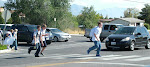
Trail crosses over 1120 North.
This is the current design proposed by American Fork city staff. Pictures and diagrams can be found on a previous post here. The main trail would travel along the west ridge of Mitchell Hollow. The trail would cross at a crosswalk on 1120 North as it nears 900 West. The city has proposed a pedestrian-activated crossing light at this location. The wetlands would pass under the road in a culvert.
Trail passes under 1120 North through a culvert.
Two culverts (10' tall x 20' wide) would be installed to pass under 1120 North. One would contain the designated wet-land areas. The other would be for pedestrian traffic. [Also being discussed: 1) One single culvert to contain both pedestrian traffic and wet-lands. 2) Enlarging the culvert designed for pedestrian traffic.]
Other.
There has been some discussion of placing a large bridge but this has been deemed too cost-prohibitive. There has also been discussion of placing water lines only, but the city has indicated that maintenance would be too difficult.

a.jpg)
See more pictures below!
Questions?
If you have questions, please send an email to AFroads@gmail.com.
Blog Archive
Who Are We?
We are a group of American Fork citizens that are concerned about Mitchell Crossing at 1120 North. We would like to make sure the trails, crossings and roadways are safe and the beauty of this area is preserved.
No comments:
Post a Comment